Saturday, December 22, 2018

MERRY CHRISTMAS 2018:


MERRY

CHRISTMAS   

2018   

FROM RockArtBlog   

 Have a very Merry Christmas, 

A Happy New Year's Eve, 

and all the best in 2018.

Saturday, December 15, 2018

GAMES IN ROCK ART - 58-HOLES, OR HOUNDS AND JACKALS:


58 Holes game board pecked
in Azerbaijan rock shelter,
Photograph W. Crist, courtesy
of the director of the
Gobustan State Historical
and Cultural Preserve.

Back in 2013 I posted a number of columns about game boards carved into rock. Now a new example has been reported from Azerbaijan, an ancient Near Eastern game called 58 Holes, or Hounds and Jackals (the name Hounds and Jackals was bestowed by Howard Carter to describe an example he found in King Tutankhamen's tomb). (Gurevich 2017)


Egyptian 58 Holes game board,
metmuseum.org - public domain.

Apparently originating in Egypt at around 2000 BCE, 58 Holes spread throughout the Near East quickly. "At least 68 gameboards of 58 Holes have been found archaeologically, including examples from Iraq (Ur, Uruk, Sippar, Nippur, Nineveh, Ashur, Babylon, Nuzi), Syria (Ras el-Ain, Tell Ajlun, Khafaje), Iran (Tappeh Sialk, Susa, Luristan), Israel (Tel Beth Shean, Megiddo, Gezer), Turkey (Boghazkoy, Kultepe, Karalhuyuk, Acemhuyuk), and Egypt (Buhen, Thebes, El-Lahun, Sedment)." (Hirst 2017)


This newly discovered example was pecked into stone in a rock shelter in Azerbaijan, some 1000 to 2000 km. from the Near East. Archaeologist Walter Crist of the American Museum of Natural History in New York City saw a photograph of the pattern online and recognized it as a board for 58 Holes. Crist contacted a colleague in Azerbaijan who helped him arrange a site visit in April 2018. "Once there, Crist found that the site he saw online had been bulldozed for a housing development. But a scientific official in Azerbaijan told him of another rock-shelter with the same dot pattern. Crist, who has studied Near Eastern versions of 58 holes, recognized the two-person game when he reached that site." (Bower 2018)

Hopefully the knowledge and recognition of this will protect this site from the bulldozer. In any event RockArtBlog is grateful for the situation that put Walter Crist in place to save it.

NOTE: Images in this posting were retrieved from the internet with a search for public domain photographs. If any of these images are not intended to be public domain, I apologize, and will happily provide the picture credits if the owner will contact me with them. For further information on these reports you should read the originals at the sites listed below.


REFERENCES:

Bower, Bruce
2018 A Bronze Age Game Called 58 Holes Was Found Chiseled Into Stone in Azerbaijan, November 16, 2018, https://www.sciencenews.org/article/bronze-age-game-found-chiseled-stone-azerbaijan

Gurevich, Eli
2017 Hounds and Jackals, October 14, 2017, http://www.ancientgames.org/hounds-and-jackals/

Hirst, Kris
2017 58 Holes: Ancient Egyptian Board Game of Hounds and Jackals, November 12, 2017, https://www.thoughtco.com/50-holes-game-169581

Saturday, December 8, 2018

GOBEKLI TEPE AND THE "MAGICIANS OF THE GODS, " BY GRAHAM HANCOCK:


Pillar 43, Gobekli Tepe, Turkey.

I have recently posted a couple of columns on the remarkable temples of Gobekli Tepe in Turkey. In these, I have expressed my fascination at the level of sophistication, and artistic accomplishment, achieved at this very early stage in the history of human culture. With something as remarkable as Gobekli Tepe, it is perhaps inevitable that fringies begin to find "hidden secrets" and predictions of coming catastrophe in it. These are perhaps best expressed in Magicians of the Gods by Graham Hancock, wherein he explains the theory that art work on one of the pillars at Gobekli Tepe actually portrays the Mayan calendrical standstill.


The pillar 43 chart of constellations,
Gobekli Tepe, Graham Hancock,
Magicians Of The GodsFigure 50.

Hancock was apparently pointed in the right direction by the writings of Paul D. Burley who discovered great astronomical meanings in Gobekli Tepe. Such is the case with the remarkable relief carvings on pillar 43. "There is a bird with outstretched wings, two smaller birds, a scorpion, a snake, a circle, and a number of wavy lines and cord-like features. At first glance this lithified menagerie appears to be simply a hodgepodge of animals and geometric designs randomly placed to fill in the broad side of the pillar. The key to unlocking this early Neolithic puzzle is the circle situated at the center of the scene. I am immediately reminded of the cosmic Father - the sun. The next clues are the scorpion facing up toward the sun, and the large bird seemingly holding the sun upon an outstretched wing. In fact, the sun figure appears to be located accurately on the ecliptic with respect to the familiar constellation of Scorpio, although the scorpion depicted on the pillar occupies only the left portion, or head, of our modern conception of that constellation. As such, the sun symbol is located as close to the galactic center as it can be on the ecliptic as it crosses the galactic plane." (Burley 2013)


The pillar 43 chart of constellations
diagrammed, Gobekli Tepe,
Graham Hancock, Magicians
Of The Gods. Page 310. 

Burley's analysis brings a couple of problems to mind for me. First, you cannot see any constellations in the sky when the sun is out and among them. You only see constellations at night when the sun is gone and the sky is dark. Why would the sun be illustrated in the middle of a star map of the night sky? Second, Burley makes great significance out of the precision of the location of this sun disk, yet the sun moves constantly while the constellations are essentially fixed for any earthbound observer. Even if you could see the sun with the constellations in the sky it would only be in any one position for an instant.


Pillar 43 with the modern
equivalent constellations,
Gobekli Tepe, Graham Hancock,
Magicians Of The GodsFigure 51.

Hancock, however, believes Burley hook, line, and sinker, but adds his own interpretation to the meaning of this star chart. It did not represent the sky back at the time Gobekli Tepe was constructed. No, it presages the sky of present-day earth. Hancock's computer work with sky simulation software proved to him that the carvings on pillar 43 were intended as some sort of message to us today. "By a process of elimination we have seen that Gobekli Tepe cannot be inviting us to consider the equinoxes, and nor can it be inviting us to consider the summer solstice, even at the favorable moment of sunset. This leaves us only with the winter solstice with the sun in Sagittarius targeting the center of the Milky Way galaxy, the definitive astronomical signature of the years between 1960 and 2040 in our own epoch - a signature that recurs only at 26,000-year intervals." (Hancock 2015:332)


Hancock's speculated constellations
charted on pillar 43, Gobekli Tepe,
Graham Hancock, Magicians Of
The Gods, Page 320.

Another comparable scientific achievement of prehistoric antiquity that survived the ages and came down to us in the same degree of completeness is the Mayan calendar "that envisaged a great cycle in the life of the world coming to an end in exactly the same 80-year period between 1960 and 2040." (Hancock 2015:333)

If I understand Hancock, the point of all of these predictions pointing to the 80-year period between 1960 and 2040 CE, is the danger of a collision with a comet. He cites a number of references to authors speculating about the possibility of large bodies in the Taurid meteor stream. "Calculations indicate that this presently invisible object at the heart of the Taurid stream might be as much as 30 kilometers in diameter. Moreover, it is thought that other large fragments accompany it." (Hancock 2015:438) Hancock's date for this disastrous collision with the earth is apparently 2030.

"The Taurids are an annual meteor shower associated with the comet Encke. The Taurids are actually two separate showers, with a Southern and a Northern component. The Southern Taurids originated from Comet Encke, while the Northern Taurids originated from the asteroid 2004TG. They are named after their radiant point in the constellation Taurus." (Wikipedia)

So now we know, both the ancient inhabitants of Gobekli Tepe, with their predictions on pillar 43, and the ancient Mayans whose calendar ended in our era because there was no point in continuing it, we are all going to be extinct, had knowledge somehow of this impending doom. Perhaps that is the "Magic" of his title, that they somehow knew about this.

I think it is really a shame to clutter up the knowledge and awareness of a magnificent place like Gobekli Tepe with this nonsense. The amazing architecture from such an early period, with the beautifully sophisticated imagery should be enough, but, for Catastrophe Theorists and the flim-flam authors who sell that stuff it never is.  

NOTE: Some images in this posting were retrieved from the internet with a search for public domain photographs. If any of these images are not intended to be public domain, I apologize, and will happily provide the picture credits if the owner will contact me with them. For further information on these subjects you should read the originals at the sites listed below.

REFERENCES:

Burley, Paul D.,
2013 Communicating Ancient Cosmic Geography, March 8, 2013, http://asabovesobelow-pauldburley.com/

Hancock, Graham
2015 Magicians of the Gods, St. Martin's Press, New York.

https://en.wikipedia.org/wiki/Taurids

Saturday, December 1, 2018

ASTRONOMY IN ROCK ART - DECODING GOBEKLI TEPE?


Gobekli Tepe, Pillar 43,
www.look4ward.co.uk,
Public Domain.


Now, to dig a little deeper into the phenomenon of Gobekli Tepe. Readers of RockArtBlog will recognize that I have an interest in the subject of natural phenomena in rock art, among these the science of astronomy. I have long believed that any remarkable natural phenomena will tend to be recorded by the people who observed them. Among these phenomena would be the close approach of a comet. Now two researchers from the University of Edinburgh have proposed that some of the marvelous carvings at Gobekli Tepe record just such an occurrence.

The remarkable recent discoveries at Gobekli Tepe, in Turkey, have given us very early architecture decorated with sophisticated stone carvings, but they have also given us (as all such discoveries seem to) new controversies concerning archaeoastronomy and the supposed comet strike that caused the Younger Dryas.

"The Younger Dryas (c. 12.900 to c. 11,700 BP) was a return to glacial conditions which temporarily reversed the gradual climatic warming after the Last Glacial Maximum started receding around 20,000 BP. It is named after an indicator genus, the alpine-tundra wildflower Dryas octopetala, as its leaves are occasionally abundant in the Late Glacial, often minerogenic-rich, like lake sediments of Scandinavian lakes." (Wikipedia)


Gobekli Tepe, Pillar 43,
Public Domain.

Gobekli Tepe, Turkish for "Potbelly Hill", is an archaeological site in the Southeastern Anatolia Region of Turkey, approximately 12 km (7 mi) northeast of the city of Sanliurfa. The tell has a height of 15 m (49 ft) and is about 300 m (980 ft) in diameter. It is approximately 760 m (2,490 ft) above sea level.
The tell includes two phases of use believed to be of a social or ritual nature dating back to the 10th - 8th millennium BCE. During the first phase, belonging to the Pre-Pottery Neolithic A (PPNA), circles of massive T-shaped stone pillars were erected - the world's oldest known megaliths. More than 200 pillars in about 20 circles are currently known through geophysical surveys. Each pillar has a height of up to 6 m (20 ft) and weighs up to 10 tons. They are fitted into sockets that were hewn out of the bedrock." (Wikipedia) It is these pillars which we are concerned with here. They are remarkably carved with low relief images and symbols, some have 3-dimensional animals, and human appendages making them stylized standing human figures.

Martin Sweatman and Dimitrios Tsikritsis, of the School of Engineering, University of Edinburgh, King's Buildings, Edinburgh, Scotland, have analyzed carvings on some of these pillars and deciphered them to tell an amazing tale. Sweatman and Tsikritsis claim they are a record of the huge comet strike that caused the Younger Dryas by reversing the climate warming, putting earth back into ice age conditions for 1,000 years. This comet strike has been amazingly difficult to locate, no remaining physical has been found so far. This has led to theories that state that the comet may have hit the earth on the ice sheet covering Canada during the late glacial age, leaving no crater in the ground.


Gobeckli Tepe, carved pillar,
the lower image is a fox.
LaStampa.it, Public Domain.

"As they are central to this work we will describe in detail a few of the key pillars of interest and their corresponding carvings. The key to unlocking our interpretation of GT is pillar 43, Enclosure D, also known as the ‘Vulture Stone’ (see Figure 1). Enclosure D is formed of a rough circular wall with eleven large upright megaliths embedded into its inner surface (once there were perhaps twelve), protruding upwards and inwards. Near the centre of the enclosure stand a pair of massive hammer-shaped megaliths, each weighing around 15 tonnes with some anthropomorphic features. We will come back to them. Pillar 43 is embedded into the north-west of the enclosure. Striking images of this pillar can be found in the academic literature and across the internet. Indeed, pillar 43 is one of the defining images of Göbekli Tepe, and has been called ‘the world’s first pictogram’." (Sweatmen and Tsikritsis, 2017)

Sweatman and Tsikritsis proceed through a very complex analysis of the imagery on pillar 43 to the conclusion that it records a dated astronomical occurrence in 10950 BC ± 250 yrs, roughly coinciding with the end of the Younger Dryas - why not the date of the event that they say began the Younger Dryas I am not able to understand. As I understand them, they say that pillar 43 sets the date and implies a catastrophe occurred, and pillar 18 indicates that it was a comet. How did the inhabitants of Gobekli Tepe, who produced this record, know of something that happened 2,000 years earlier?

"We have interpreted much of the symbolism of Göbekli Tepe in terms of astronomical events. By matching low-relief carvings on some of the pillars at Göbekli Tepe to star asterisms we find compelling evidence that the famous ‘Vulture Stone’ is a date stamp for 10950 BC ± 250 yrs, which corresponds closely to the proposed Younger Dryas event, estimated at 10890 BC. We also find evidence that a key function of Göbekli Tepe was to observe meteor showers and record cometary encounters. Indeed, the people of Göbekli Tepe appear to have had a special interest in the Taurid meteor stream, the same meteor stream that is proposed as responsible for the Younger-Dryas event. Is Göbekli Tepe the ‘smoking gun’ for the Younger-Dryas cometary encounter, and hence for coherent catastrophism?" (Sweatman and Tsikritsis)

The date designated has been arrived at by assuming the circle seen in what is roughly the center of pillar 43 (the Vulture Stone) as the sun, and the other images on the face are identified as constellations. Apparently running the (assumed) identified constellations back in a computer to the positions they occupy on pillar 43 gives the date 10950 BCE ± 250. The other pillar involved in this interpretation is pillar 18 of Enclosure D. Its imagery identifies the causal event of the Younger Dryas, a comet strike on earth. The comet is proven by the image of a fox with the foxes' tail representing the comet. (Sweatman and Tsikritsis)

I have read their paper and I must say I am not convinced. They state, in many instances, that some carved symbol carries a certain meaning, but present no evidence to back that up. We have the same criticisms here that I have found pertinent in other claimed prehistoric star charts, and a star chart is exactly what they are claiming pillar 43 is. However, a picture of a scorpion provides absolutely no proof whatsoever that the ancient inhabitants identified the same Scorpio constellation as we do, or any Scorpio constellation at all, for that matter. They might have seen those stars as representing anything at all. They might have looked up at the constellation of the rabbit's genitals for all we know. A picture of a scorpion proves nothing. I will look more deeply into these constellations and star charts in my next column.

It is, perhaps, inevitable that catastrophe theorists would find ways to involve something as remarkable as Gobekli Tepe in their crazy ideas. The press has loved this story by Sweatman and Tsikritsis, but I have not found much in the way of assent from the scientific community. It is a shame that some people cannot just admire it for what it is, amazingly early examples of temple architecture and remarkable artwork combined in one place, produced thousands of years earlier than most other known examples, a miracle of human creativity. Not everything encodes secret messages! I do, however, urge you to read their paper for yourself and make up your own mind. 

NOTE: Some images in this posting were retrieved from the internet with a search for public domain photographs. If any of these images are not intended to be public domain, I apologize, and will happily provide the picture credits if the owner will contact me with them. For further information on these reports you should read the original listed below.

REFERENCES:

Sweatman, Martin B., and Dimitrios Tsikritsis
2017 Decoding Gobekli Tepe With Archaeoastronomy: What Does The Fox Say?, p. 233-50, Mediterranean Archaeology and Archaeometry (open access), Vol. 17, No. 1.

https://en.wikipedia.org/wiki/Göbekli_Tepe

https://en.wikipedia.org/wiki/Younger_Dryas

LaStampt.it

www.look4ward.co.uk

www.suggestkeywords

Sunday, November 25, 2018

GOBEKLI TEPE - 12,000-YEAR-OLD TEMPLES?


View of Gobekli Tepe temple excavation, tse2.mm.bing.net,
Public Domain.

I am writing this as an introduction to the remarkable phenomenon of Gobekli Tepe. I have no intention to make this any more than a simple introduction, in hopes of inspiring you, my readers, to dig in to the subject yourselves. Gobekli Tepe will reward your efforts.


Pillar with relief sculpture,
birds and boar,
3.bp.blogspot.com-gobekli-tepe-3,
Public Domain.

"Gobekli Tepe, Turkish for "Potbelly Hill", is an archaeological site in the Southeastern Anatolia Region of Turkey, approximately 12 km (7 mi) northeast of the city of Sanliurfa. The tell has a height of 15 m (49 ft) and is about 300 m (980 ft) in diameter. It is approximately 760 m (2,490 ft) above sea level. The tell includes two phases of use believed to be of a social or ritual nature dating back to the 10th - 8th millennium BCE. During the first phase, belonging to the Pre-Pottery Neolithic A (PPNA), circles of massive T-shaped stone pillars were erected - the world's oldest known megaliths. More than 200 pillars in about 20 circles are currently known through geophysical surveys. Each pillar has a height of up to 6 m (20 ft) and weighs up to 10 tons. They are fitted into sockets that were hewn out of the bedrock." (Wikipedia)


Gobekli Tepe, pillar carved
with arms and a belt,
www.ancient-origins.net,
Public Domain.

The main site of Gobekli Tepe consists of a series of circular constructions as described above. Remarkably, each one was apparently used for some time and then buried, with a new circular construction built for use. Four of the circular constructions have been excavated with a probably 16 more still to be investigated. Indeed, T-shaped stone pillars have reportedly been found on a number of other hilltops in the region indicating the possibility that the phenomenon of Gobekli Tepe was widespread. (Wikipedia)


Lion and boar on a pillar
at Gobekli Tepe,
tse1.mm.bing.net,
Public Domain.

Gobekli Tepe is classified as a Pre-Pottery Neolithic A Period site, and "is a series of mainly circular and oval-shaped structures set on the top of a hill. Excavations began in 1995 by Prof. Klaus Schmidt with the help of the German Archeological Institute. There is archeological proof that these installations were not used for domestic use, but predominately for ritual or religious purposes. Excavations and geo-magnetic results revealed that there are at least 20 installations, which in archeological terms can be called a temple. Based on what has been unearthed so far, the pattern principle seems to be that there are two huge monumental pillars in the center of each installation, surrounded by enclosures and walls, featuring more pillars in those set-ups." (gobeklitepe.info)


Three-dimensional lion
carved on a pillar,
gobeklitepe.info,
Public Domain.

It is these pillars which we are concerned with here in RockArtBlog. They are remarkably carved with low relief images and symbols, some have three-dimensional animals, and human appendages making them stylized standing human figures. They comprise a remarkable collection of stunning early art.

Dating of the various layers has given a range of dates from 9130 - 7370 BCE (Wikipedia), with the largest and most ornate constructions tending to be from the earlier period. This means that 12,000 years ago, before humans had invented farming or pottery, the people of Gobekli Tepe were carving stone, building temples, and sculpting stone figures. Most of the stone carving is in relief, but a few examples are three-dimensional. All-in-all they comprise an incredibly sophisticated complex from a very early period.

NOTE: Some images in this posting were retrieved from the internet with a search for public domain photographs. If any of these images are not intended to be public domain, I apologize, and will happily provide the picture credits if the owner will contact me with them. For further information on these reports you should read the originals at the sites listed below.


REFERENCES:

https://www.ancient-origine.net/ancient-places-asia/decoding-g-bekli-tepe-secret-society-and-space-observatory-008687

https://en.wikipedia.org/wiki/Göbekli_Tepe

http://gobeklitepe.info/first-symposium-on-gobeklitepe.html

Wednesday, November 14, 2018

BORNEO CAVE ART CLAIMED WORLD'S OLDEST ANIMAL IMAGE:


Panel from Borneo cave,
handprints at top right,
banteng at lower left.
www.livescience.com.

As more and more discoveries are made around the world it becomes increasingly obvious that the only thing special about the cave art in Europe is that it has been studied much more than elsewhere. Increasing attention to rock art in other parts of the world are now challenging all previous assumptions about who, what, and where was first. In other words our cultural-centric biases are showing.

"A 40,000-year-old painting of a mysterious, wild cow-like beast discovered in a Borneo cave is the oldest human-made drawing of an animal on record. The discovery indicates that figurative cave art - one of the most significant innovations in human culture - didn't begin in Europe as many scientists thought, but rather in Southeast Asia during the last ice age." (Geggel 2018)

"Previously, the oldest known animal painting in the world was an approximately 35,400-year-old babirusa, or "pig-deer," on the Indonesian island of Sulawesi." (Geggel 2018)


Banteng on panel from Borneo cave,www.livescience.com.


"A limestone cave in eastern Borneo features a reddish-orange painting of a horned animal, possibly a type of wild cattle that may have been found on the island at the time. The painting dates to at least 40,000 years ago, concludes a team led by archaeologist Maxime Aubert of Griffith University in Southport, Australia. This creature represents the oldest known example of a painted figure anywhere in the world the scientists report online November 7 in Nature." (Bower 2018)

Male banteng,.
http://zoochat.com, 
public domain.

A species of wild cow known as the banteng (Bos javanicus) still lives in the forests of Borneo and this image might represent the banteng, or an unknown prehistoric relative. In the banteng the horns are considerably larger on the male, as seen in this cave painting.

"The same cave walls contain two hand outlines framed in reddish orange pigment that were made at least 37,200 years ago, and a similar hand stencil with a maximum age of 51,800 years. Age estimates rest on analyses of uranium in mineral deposits that had formed over and underneath parts of each cave painting. Scientists used known decay rates of radioactive uranium in these deposits to calculate maximum and minimum dates for the paintings." (Bower 2018)

"The researchers collected calcium-carbonate samples from the Kalimantan cave drawings so they could do uranium-series dating - a technique made possible by radioactive decay. When rainwater seeps through limestone, it dissolves a small amount of uranium, Aubert told Live Science. As uranium decays, it turns into the element thorium. By studying the ratio of uranium to thorium in the calcium carbonate that is coating the cave art, researchers determined how old the initial coating was, he said." (Geggel 2018)

This is a good hard dating for these images, something not always available for rock art.


Handprints from Borneo cave,
red-orange are earlier, the
darker ones are later.
www.sciencenews.org.

"The team proposed that the prehistoric artworks can be divided into at least two chronologically distinct phases of art production. The first phase is characterized by hand stencils and large figurative paintings of animals that are reddish-orange in colour." (Brumm 2018)

"Hand stencils also characterize the later phase, but these stencils (and associated images) tend to be dark purple ("mulberry") in colour." (Brumm 2018)

The recently dated images from the Indonesian island of Sulawesi, and now these even earlier dates, should put to rest our old assumptions of cultural imperialism. Just because the rock art in Europe was found first, and studied the most extensively, does not mean that the Paleolithic Europeans were culturally more advanced. Indeed, with these new dates from the other side of the world it looks like we have some catching up to do.

NOTE: Some images in this posting were retrieved from the internet with a search for public domain photographs. If any of these images are not intended to be public domain, I apologize, and will happily provide the picture credits if the owner will contact me with them. For further information on these reports you should read the originals at the sites listed below.

REFERENCES:

Bower, Bruce,
2018 Like Europe, Borneo Hosted Stone Age Cave Artists, November 7, 2018, https://www.sciencenews.org/article/oldest-known-drawing-figure-found-cave-art-borneo

Brumm, Adam,
2018 Borneo Cave Discovery: Is the World's Oldest Rock Art in Southeast Asia?, November 8, 2018, https://www.viw.com.au/index.pho/news/16298-borneo-cave-discovery-is-the-world-s-oldest-rock-art-in-southeast-asia

Geggel, Laura,
2018 World's Oldest Animal Drawing, Discovered in Borneo Cave, Is a Weird       Cow Beast, November 7, 2018, https://www.livescience.com/64034- oldest-figurative-cave-art.html

http://photos.zoochat.com

Saturday, November 10, 2018

A RIDICULOUS CLAIM - THE EGYPTIAN PYRAMIDS ARE ORIENTED TO THE STARS IN ORION'S BELT:


A supposed alignment of
the stars in the belt of the
constellation Orion with the
peaks of the Giza pyramids
in Egypt.

This is not strictly speaking about rock art, but it is such an egregious example of New Age fringie thinking that I felt I had to say something about it.


I recently ran across an article with this reference (Shreya below) about the pyramids of Giza Plateau in Egypt being aligned with the stars of the belt of the constellation Orion. Now, while we all know that ancient peoples would have seen the sky and probably picked out patterns in it just as we do, some of the supposed "ancient knowledge" about this is pretty weak. We have a whole cabal of New Agers and spiritualists who pretty much make up "ancient knowledge" out of the whole cloth. I decided to look a little deeper into this knowing that in ancient Egypt there actually was a body of sky knowledge.

A modern star chart of
the constellation Orion.

"In ancient Egypt, the stars of Orion were regarded as a god, called Sah. Because Orion rises before Sirius, the star whose heliacal rising was the basis for the Solar Egyptian calendar, Sah was closely linked with Sopdet, the goddess who personified Sirius. The god Sopdu, was said to be the son of Sah and Sopdet. Sah was syncretized with Osiris, while Sopdet was skyncretized with Osiris mythological wife, Isis. In the Pyramid Texts, from the 24th and 23rd centuries BC, Sah was one of many gods whose form the dead pharaoh was said to take in the afterlife." (Wikipedia)

"The pyramids named Khufu, Khafre and Menkaure are aligned with the stars (Alnitak, Alnilam, and Mintaka) of the Orion belt (a constellation in the night sky). No one knows, till date(?), how the Egyptians could have achieved this feat of aligning the pyramids with the celestial bodies. Orion was not even named till 2,000 years after the pyramids were made but it is believed that the constellation was linked with Osiris God of Rebirth, by the Egyptians." (Shreya 2018)
This is such a wonderful example of  New Age fringie thinking that I had to pass it along to you. Let's begin with the phony photograph illustrating it - Oh, the wonders of PhotoShop! This picture is phony. I am not versed in astronomical mathematics, but even I can do a few simple calculations that prove this. 

First, by my simplistic measurements off of a star chart the belt of Orion subtends approximately 3˚  (degrees) of arc, and measuring off of a map of the Giza Plateau from peak to peak the distance between the outer two pyramids is 900m. So for this photo with the stars of Orion's belt so perfectly aligned to the peaks of the pyramids to work, the peaks of the two outer pyramids have to be 3˚ apart too. If each 3˚ of the arc is 900m then the circumference of the full circle is 108,000m. This give us a diameter of the circle at 34,394.90m (d=C/n), and half of that is the radius, the viewing point at which the pyramids would appear to subtend 3˚ of arc is the center. This radius comes to 17,197.45m (56,422 feet), or 10.7 miles. Do you really believe that the pyramids of Giza look that large and impressive from almost eleven miles away? 

Well, you say, the picture could have been taken with a telephoto lens from that far away and the peaks of the two outer pyramids would be 3˚ of arc apart just like Orion's belt. Then I have to ask you what brand of telephoto lens the ancient Egyptians used, and if you actually think you have an answer for that then we have nothing more to discuss.

Diagram showing that
there is no alignment.

Then we have the question of their supposedly perfect alignment. I went back to my star chart and map of the Giza plateau and drew lines from the stars through the peaks of the pyramids and to a viewing point, and they don't line up properly. You can change the size of the spread of the stars or its angle (remember Orion moves through the sky and its angle changes), but you cannot change the relative distances between the stars, or the pyramid peaks, and no matter how you try to adjust it, they will never line up.


Hancock, Graham, Magicians of
the Gods, 2015, page 504.

For some reason, Graham Hancock, in his 2015 book Magicians of the Gods, decided to throw in with this nonsense as well. He sees it as supporting his premise of ancient knowledge lost to our modern age. I find his explanation (Hancock 2015:504) no more convincing than the others, indeed, the fact that he sees it as more proof of his claims of ancient lost knowledge argues very effectively against this theory in my opinion. (I will not quote him here but will refer you to his book if you are interested in pursuing this theory).

So, this story is just more of the New Age fringie fiction which is so unfortunately common in our anti-scientific society. And admittedly, my crude analysis above is based upon my own gonzo astrophysical calculations, and I would welcome a more scientific and accurate analysis, but until that occurs I will stand by my conclusions.

NOTE: Some images in this posting were retrieved from the internet with a search for public domain photographs. If any of these images are not intended to be public domain, I apologize, and will happily provide the picture credits if the owner will contact me with them. For further information on these reports you should read the originals at the sites listed below.

The hieroglyphics were provided by http://quizland.com/hiero.mv as a translation for "bullshit". As always, one-on-one translations will be incorrect because their word would not have necessarily a direct equivalent for our word.

I will welcome the help of any mathematician or astrophysicist who would like to refine my crude calculations and examples. Send them to me and I will be happy to post them here on https://rockartblog.blogspot.com.

REFERENCES:


Hancock, Graham
2015 Magicians of the Gods, St. Martin's Press, New York.

https://en.wikipedia.org/wiki/Orion_(constellation)

Shreya,
2018 Pyramids Were Constructed 1000s of Years Ago but Some Facts About Them are Still Astonishing, August 14, 2018, https://newsd.co/pyramids-constructed-1000s-years-ago-facts-still-astonishing/9/?k=y3452&adb2=1&sp=2

http://quizland.com/hiero.mv

Saturday, November 3, 2018

ANOTHER BOGUS PALEOLITHIC STAR MAP - THE ACH VALLEY TUSK:


Ach Valley carved mammoth
ivory, www.astronomytrek.com.
Public domain.

There is an old piece of advice that states "if you can't say something nice about someone, don't say anything at all." This is obviously very good advice for human interaction, but there are circumstances where erroneous or dangerous ideas are being passed on, that I believe must be called out for what they are. I have recently been writing a series of columns about the theories of Dr. Michael Rappenglueck, who identifies star charts in Paleolithic art. I have tried to patiently point out what I think are the flaws in his reasoning and shown how I disagree with his conclusions. This example, however, is even shakier than the others.

The Ach Valley Tusk is a piece of mammoth ivory, recovered from Geißenklösterle Cave near Ulm, Germany, that has a human figure carved into one side and a series of 86 pits or notches cut into the other. Rappengluek identified the human figure as a star map representing the constellation Orion.


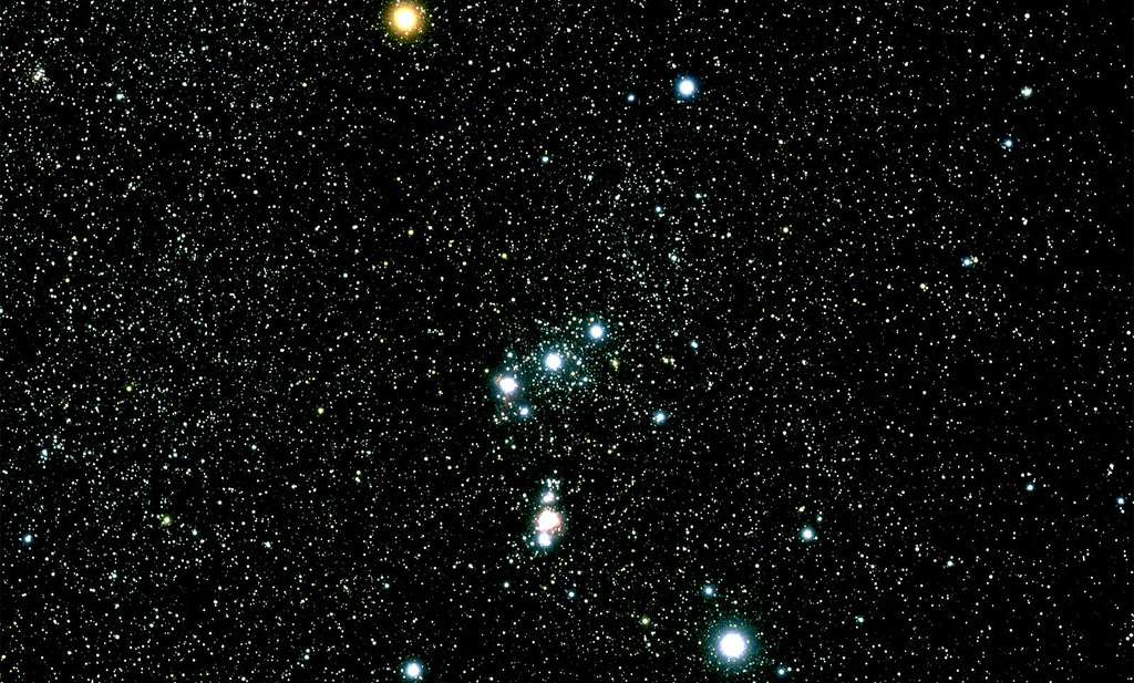
Constellation Orion star chart,
www.ancient-origins.net,
Public Domain.

"Orion is a prominent constellation located on the celestial equator and visible throughout the world. It is one of the most conspicuous and recognizable constellations in the night sky. It was named after Orion, a hunter in Greek mythology. Its brightest stars are Rigel (Beta orionis) and Betelgeuse (Alpha orionis), a blue-white and a red supergiant, respectively.
The earliest depiction that has been linked to the constellation of Orion is a prehistoric (Aurignacian) mammoth ivory carving found in a cave in the Ach valley in West Germany in 1979. Archaeologists have estimated it to have been fashioned approximately 32,000 to 38,000 years ago. The distinctive pattern of Orion has been recognized in numerous cultures around the world, and many myths have been associated with it." (wikipedia.org/wiki/Orion)


Constellation Orion, NASA,
Public Domain, atoday.org.

Writing on astronomytrek.com, Peter Christoforou, explained the proposition. According to Christoforou "Dr. Michael A. Rappengluck is well respected in academic circles, and has a solid grounding in both astronomy and the history of astronomy. In fact, Dr. Rappengluck holds an advanced degree in the History of Astronomy from the University of Munich, and he has served as the President of the Society of Archaeaoastronomy in Germany." (Christoforou 2018)

"According to research published by Dr. Rappengluck, the figure must be Orion, since the slim waist of the figure corresponds to the Belt of Orion, and the sword he sees hanging from the waist of the figure is easy to see in the real constellation. Moreover, Dr. Rappengluck is at some pains to point out that the figurines' left leg is somewhat shorter than the right leg, just as it is in the constellation. Therefore, the figure on the ivory fragment is Orion the Hunter." (Christoforou 2018) I feel I should take this opportunity to point out that the writer Peter Christoforou has gone out of his way to be fair to Rappenglueck, even if he is not convinced of the carving's identity as Orion (and I urge you to read his whole paper at the address below) he has given all the arguments, pro and con.

The usual arguments still apply, but in this case a couple of new ones come into play as well. First, thousands of bone, ivory, and antler carvings were recovered from Geißenklösterle Cave but this is the only one that portrays a constellation? To make this argument Christoforou pointed to a carving of a bison. "This figuring of a bison shows some simple bas-relief in addition to faint details like horns and a beard, despite the fact that it measures only 25.5mm x 14.5 mm x 6 mm, which is comparable to the dimensions of the human-like figure of the putative Orion star map. The original carving is housed in the Wurttemberg Landesmuseum, Stuttgart.
While the existence of this particular carving (the bison) does not prove anything beyond the fact that it shows exquisite workmanship, it is significant that neither Dr. Rappenglueck, nor any other archeaoastronomers have suggested that the figure represents the constellation Taurus, or any other constellation. Of course, this does not prove that the Orion carving is not a star map, but the point is that only one artifact from among the thousands recovered from the cave is taken to represent a constellation. By all accounts, this is rather strange considering the sheer amount of artifacts that could be taken as star maps, or representations of the objects/patterns in the night sky." (Christoforou 2018)

The other obvious problem is, of course, the sword that Rappenglueck sees hanging from the figure's belt, and that identifies him as Orion. Is it really like all the other known Paleolithic swords to be so convincing? Oh wait, what's that you say, there are no Paleolithic swords? What was I thinking of?

Another issue is the fertility connection that Rappenglueck imbues this carving with. Remember the 86 notches on the back of the carving? "The average length of human gestation is 280 days, or 40 weeks." (www.betterhealth.vic) Rappenglueck noted that if you subtract the 86 notches from the number of days in a year you have a number that is very close to the average length of modern human pregnancy. (The only references I have been able to find about the length of pregnancy in the Paleolithic period assume that it was the same as today).
"The reverse side of the Orion carving is dotted with 86 notches, which Dr. Rappanglueck claims is a "birth calendar". According to Dr. Rappenglueck, if one subtracts 86 from the number of days in a year (365), one arrives at the average human gestation period, which is around 279 days, or nine months, gave or take a few days either way. Nevertheless, this implies that the Aurignacian culture could count, that they knew how many days there were in a year, and that they understood and practiced basic arithmetic." (Christoforou 2018)

I am going to give them some benefit of the doubt here - I assume that the Aurignacian peoples could count. I find it inconceivable that they would have reached such cultural heights and overlooked counting. I even assume that they could understand and practice simple basic arithmetic. I am less convinced that they knew the number of days in a year - 12 moons, yes, but the actual number of days in a year, I don't know. This, however, makes no difference. What kind of pregnancy calculation is made by subtracting 86 days from the end of a year, when you don't know at what point the year started (when the pregnancy began)?

"Moreover, Dr. Rappenglueck also claims that the 86 notches on the carving represent the number of days that one of Orion's principal stars, Betelgeuse, is visible, thus forming a link between the sky gods and human fertility." (Christoforou 2018)

This last statement is particularly confusing because the truth is that Betelgeuse is visible all year except for June and July when they are in the sky during daylight hours. "In the Northern Hemisphere, beginning in January of each year, it can be seen rising in the east just after sunset. By mid-September to mid-March (best in mid-December), it is visible to virtually every inhabited region of the globe, except for a few research stations in Antarctica at latitudes south of 82˚. In May (moderate northern latitudes) or June (southern latitudes), the red supergiant can be seen briefly on the western horizon after sunset, reappearing again a few months later on the eastern horizon before sunrise. In the intermediate period (June-July) it is invisible to the naked eye (visible only with a telescope in daylight) - - . " (wikipedia.org/wiki/Betelgeuse)

All in all, this Orion figurine is the most egregious of Rappenglueck's claimed identifications of Paleolithic star maps, and I find it totally unbelievable.

NOTE: The pictures in this posting were retrieved from the internet with a search for public domain images. If they were not meant to be public domain please contact me and I will give full credit.

REFERENCES:

Christoforou, Peter
2018 Is the Ach Valley Tusk-fragment an Ancient Star Map?, March 2, 2018, https://www.astronomytrek.com/is-the-ach-valley-tusk-fragnebt-an-ancient-star-map/

https://en.wikipedia.org/wiki/Betelgeuse

https://en.wikipedia.org/wiki/Orion_(constellation)

https://www.betterhealth.vic.gov.au/health/healthyliving/baby-due-date

NASA

www.ancient-origins.net

www.astronomytrek.com